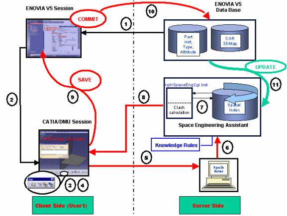
How does it work ?
![]() Data coming from
the ENOVIA LCA data base (please refer to "Set Up the ENOVIA Data base" in
the Enterprise Architecture Installation Guide), an ENOVIA LCA
Client session is running, the Product Editor is opened
Data coming from
the ENOVIA LCA data base (please refer to "Set Up the ENOVIA Data base" in
the Enterprise Architecture Installation Guide), an ENOVIA LCA
Client session is running, the Product Editor is opened
![]() The user sends
data into CATIA V5 session (using the Send to... command);
the connection between CATIA and ENOVIA has been previously established.
The user sends
data into CATIA V5 session (using the Send to... command);
the connection between CATIA and ENOVIA has been previously established.
Zooming on CATIA/DMU Session section:
![]() The user connects
to the host server, he either chooses between:
The user connects
to the host server, he either chooses between:
-
Automatic connection:
Please read Tools > Options > Digital Mockup > DMU Space Engineering
-
Manual connection:
In this case, all he needs to is click the Connection icon in the Space Engineering Assistant toolbar.
![]() The user works in
session, in our example, let's say he selects the part floor and moves it.
The user works in
session, in our example, let's say he selects the part floor and moves it.
![]() The user needs to
launch SPE computation, clicking Force computation of clashes with
committed models
The user needs to
launch SPE computation, clicking Force computation of clashes with
committed models
![]() in the
Spy toolbar. A request is then sent to the Apache HTTP server.
in the
Spy toolbar. A request is then sent to the Apache HTTP server.
![]() The information
(part identifier) is passed to the Spatial index (permanent running
process).
The information
(part identifier) is passed to the Spatial index (permanent running
process).
![]() The Spatial index
runs a proximity query and performs other checking operations: the
resulting data is sent to the Design Assistant server (nphSpaceEngCgi.bat)
which performs the clash calculation with respect to the
Knowledge clash Rules specified. Please refer to
More About Knowledge Clash Rules.
The Spatial index
runs a proximity query and performs other checking operations: the
resulting data is sent to the Design Assistant server (nphSpaceEngCgi.bat)
which performs the clash calculation with respect to the
Knowledge clash Rules specified. Please refer to
More About Knowledge Clash Rules.
![]() Clash results are
sent to CATIA V5
Clash results are
sent to CATIA V5
![]() Clash results are
displayed in the Check clash dialog box (accessed via the Browse clash
result with committed models icon).
Clash results are
displayed in the Check clash dialog box (accessed via the Browse clash
result with committed models icon).
![]() The user can then
modify the status of one detailed clash result, add comments in the DMU
Clash dialog box. These (modified) clash results will be stored
automatically in ENOVIA V5 while saving his session in ENOVIA LCA.
The user can then
modify the status of one detailed clash result, add comments in the DMU
Clash dialog box. These (modified) clash results will be stored
automatically in ENOVIA V5 while saving his session in ENOVIA LCA.
![]() In the ENOVIA
LCA session, the user clicks the Refresh icon and searches for
the clash result.
In the ENOVIA
LCA session, the user clicks the Refresh icon and searches for
the clash result.
-
Saving operation is launched in the ENOVIA Data Base
-
Clash results computed with Space Engineering Assistant based on Knowledge Clash Rules and created in CATIA are displayed and refreshed in the ENOVIA LCA session.
![]() The ENOVIA Data
Base passes the information to the Spatial index which is automatically
updated accordingly taking into account the modified objects.
The ENOVIA Data
Base passes the information to the Spatial index which is automatically
updated accordingly taking into account the modified objects.
![]()