-
Multi-select the points on one of the views or on all views.

-
Click Coordinate Dimension Table
 in the Dimensioning toolbar.
")
Points coordinates tables cannot be associative. Selecting an element in the drawing does not make the table associative to this element. The Axis System and Table Parameters dialog box is displayed.
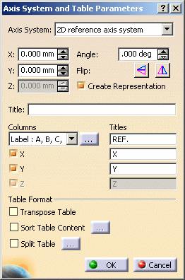
This dialog box contains the following options:
-
Axis system:
You can choose to use the 2D reference axis system. It can be either the one of the view or user-defined. In this case, it can be defined by typing the origin coordinates in the X and Y fields, or interactively by either:-
indicating a point by clicking in the view
-
selecting a point
-
selecting two lines.
-
You can rotate or flip the axis using the Flip horizontally and Flip vertically icons and choose to represent the axis system by checking the Create representation box.
Or you can choose to use the 3D absoluet axis system. In this case, it is the absolute axis of the 3D model, or, if the model is a single part, a local axis.
-
Title: Type the table title.
-
Columns:
-
Choose a label (A, B, C... or 1, 2, 3...). If you want column numbering to start with values other than A or 1, click the icon
 and specify the start value.
 -
Select and name the column to display.
-
-
Table format:
-
Select the Transpose table check box to invert columns and rows.
-
Select the Sort table content check box to sort the table elements.
-
Select the Split table check box to split the table into several tables. For more information on splitting tables, see Creating/Modifying a table.
-
-
-
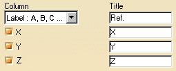
Choose Axis system.1 for the axis system from the associated drop-down list.
-
Type the table name in the Title field.
-
Select Label: A, B, C from the Column drop-down list (you can also choose the Index naming mode) to give a label to the selected points in the drawing.
-
Select the X, Y and Z check boxes to create four columns corresponding to the points labels and to the Cartesian coordinates. Then enter a title for each column in the associated field.
-
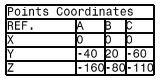
Select the Transpose table check box to invert columns and rows in the table.
-
Select the Sort table content check box and then click the [...] icon
to
define the sorting parameters.
The Sort dialog box is displayed.
-
To sort the table by descending X coordinates, choose X in the Sort by combo box, and select Descending. Then, click Close.
. Note that once you validate the creation of the points coordinate table (by clicking OK in the Axis System and Table Parameters dialog box), you will no longer be able to edit these dimension properties. Also note that you can not edit Coordinates Table precision value through style customization. -
Click OK in the Axis System and Table Parameters dialog box to validate your settings and click in the drawing to define the location of the table. The table is generated.
![]()